At a Glance
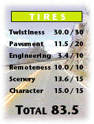
Where speed tax collectors fear to tread?
While we can’t guarantee anything, we’ve never seen any on this
road. It’s easy to see why
they’re afraid of debasing this DH with their presence.
The power of this challenging road is obvious from the moment you
embark upon the long, corkscrew climb out of the Pemberton Valley.
As you venture into the spectacular mountains of the Cayoosh Range,
the barrage of curves is intense. They
don’t let up when you pass along the dramatic shoreline of Duffey Lake, or even in the final section where you’ll be awestruck by
the spectacular, winding canyon descent to the town of Lillooet. True, engineering can be quirky and pavement quality can vary
markedly from one season to the next.
However, it’s simply impossible to resist the combination of zero
development, sensational scenery and endless, diverse twisties.
Perhaps the STCs are up here, after all.
We just don’t recognize them when they’re off duty, decked out
in full leathers, aboard ZX12s.
Access
From
Mount Currie
On
Hwy 99
Turn right at the signed
junction to Lillooet just past the small white church.
You are on the road.
From
Lillooet
Coming
in on DH21 Hat Creek - Lillooet (Hwy 99)
Coming
in on DH40 Lytton - Lillooet (Hwy 12)
Both DHs end at the bridge to Lillooet.
Take it west over the Fraser River and turn left
at the other end. (A
right turn takes you into Lillooet.)
When you leave the remaining bits of town, you're on the road.
On The Road
Mountains on
both sides of the Pemberton Valley surround you as you wind through the
deciduous trees and open fields of the Lillooet River delta.
The Mount Currie Indian Reservation can lay claim to some great
curves in this stretch along the river.
The pavement is excellent as well-- that is if you can find it
between the numerous greasy tar strips.
They’re probably the reason for the 60-kmh (40-mph) zone.
At 8.9 km (5.6 mi), you cross the Lillooet River as it empties into
immense, silt- coloured Lillooet Lake.
After briefly tracking the shoreline, you start a winding climb, at
9.9 km (6.2 mi), up into the forest.
You still have to contend with tar strips, but they’re less
plentiful as you move north and away from the lake.
Two wide, back-to-back hairpins are but an example of the wild
second- and third-gear entertainment on this show-stopping ascent.
The pavement drops a grade and the tar strips disappear altogether
when the pitch eases at 13.4 km (8.4 mi).
The ascent continues, more gradually and less twistily now, as the
high, often barren peaks of the Cayoosh Range loom above the trees. At 23.1 km (14.6 mi), you climb past the turnoff right to the
Joffre Lakes day-use recreation area.
The road spans Cayoosh Creek and, after a few tight curves, pops
from the trees and flattens out at 26.9 km (16.9 mi). What a long, great climb it's been.
Now on the west side of the high, mountain valley, the road lies
hard against the jumbled slope. With
the curves mellowing, you might take a moment to check out your
surroundings. Boggy alpine
meadows of pink wildflowers lie to the east.
Beyond that, on the valley’s far side, large clearcuts scar the
lower mountain slopes. But
back to business. A
contingent of multiple esses escorts you down the slope, where a last
corner shoots the DH sharply east across the valley floor and onto a
one-lane wooden bridge over Cayoosh Creek at 34.5 km (21.7 mi).
Another sharp turn and you’re winding north again, through the
trees on the east side of the valley.
Somewhere along here, you exit the logging havoc and enter Duffey
Lake PP. As you curve along the lake at 37.0 km (23.3 mi), the
milky-green water is intermittently screened by a thin curtain of trees.
Play in the esses is limited not only by the bumpy pavement, but by
motor homes lurching unpredictably from the pullovers.
Across the lake, green avalanche chutes streak down the brown ridge
that rises steeply from the far shore.
The bottom of these chutes seems a perfect place for some
designated RV parking.
At 42.8 km
(27.0 mi), you reach the northern tip of the lake where exuberant Cayoosh
Creek springs back to life. The
valley narrows and the road climbs the rockfaces on its east side.
In so doing, it delivers some good, but sometimes blind, corners.
These curves stick around even when you return to the valley floor
at 46.0 km (29.0 mi).
You’ll note it’s
getting warmer as you escape the cold, coastal air and approach the
interior. You will also note
the consistent absence of people, civilization and traffic.
What remains? Just the
mountains, creek, forest and ribbon of grey below, blended into one by
your right wrist. Are you in a state of Zen?
Or an ad for the Kawasaki Nomad?
The valley widens and the radius of the still numerous curves
lengthens a tad. You cross
Cayoosh via another wooden one-laner at 55.1 km (34.7 mi).
More back and forth across the valley floor until yet one more
single-lane woody puts the creek back on your left at 60.1 km (37.3 mi).
The valley narrows dramatically now, twisting back and forth,
forcing road and creek to follow. High
above, dry, steep mountain ridges rake the sky.
The right side of the road cycles through steep cliffs, slides,
crumbling sedimentary rock and flat areas before you enter a straighter,
more open high-speed stretch. At
73.0 km (45.3 mi), the valley tightens its grip again and the road starts
an up down sequence. Tighter curves return with the steeper terrain.
You might want to stop mid-sweeper at the Grubstake Grill at 75.7
km (46.9 mi). Hidden in the
bush, this stand serves the very best hot dogs, coffee and potato chips
you’ll find anywhere between Mount Currie and Lillooet.
Past the pit stop, you climb and carve through more of this DH’s
seemingly endless curves. Across
the canyon, whole sides of the vertical mountains seem to have sheared
right off. You hope the same
thing doesn't happen to the equally intimidating rock on your immediate
right.
The road
descends, crosses the last wooden trestle over Cayoosh Creek at 78.8 km
(48.9 mi) and immediately starts to climb.
As you edge high above the creek, you’ll note the sheer rockfaces
are now on your left. Incredibly,
the gargantuan mountains across the gorge make the earlier ones seem like
mere hills. The magnificent scenery is complemented by the tight, linked,
though sometimes blind, corners coming at you in waves.
At 82.2 km
(51.0 mi) the 13-per cent grade advisory signals the beginning of the
DH’s final descent. You’ll
feel the blast of Lillooet’s dry summer heat as you negotiate two steep
hairpins through the drying terrain.
A right corner takes you out of Cayoosh canyon at 85.5 km (53.0
mi). The road points east, high above the Seton River.
Further east, the peaks of Fountain Ridge soar through a gap in the
mountains on either side of the Seton’s short, but deep valley.
A third hairpin turns you back north past the viewpoint over
the long, turquoise expanse of Seton Lake, glistening to the west between
yet more steep mountains. Directly
north, the massive, bare, taupe rock of Cayoosh Wall looms above the Seton
River. One more corner and
the road descends east to the valley floor, touching down at 87.5 km (54.3
mi). A few more gentle curves
along the river and a fish channel, two last wooden bridges and your
journey ends in Lillooet's outskirts at 89.8 km (55.7 mi).
NOTE:
As good as the scenery is going in this direction, it's even better going
the other way. You'll also
get to re-enjoy this excellent ride from a different perspective.
Highly recommended.
Twisted Edges
TE-A
Mount Currie – D’Arcy (37.4
km / 23.2 mi)
You’ll
find good pavement on this nicely winding, lightly travelled run up a
heavily treed, mountain-ringed, coastal valley.
Stop signs at the many B.C. Rail main line crossings slow you down.
So does the occasional blind corner.
|
|
|
|