|
| |
 |
DH5
Happy Camp - Willow Creek
Highway 96 |
 |
|
 At a Glance
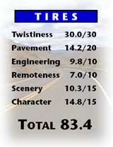
Mirror, mirror on the wall. Who’s the
fairest road of all? Well actually, DH1
dwells in a different region. But not
to worry. Though its Character’s not
perfectly snow-white, even Grumpy
would love this long, remote and
pretty-darn-fair ride along the rugged
cliffs of the Klamath and Trinity
Rivers down from Happy Camp.
The Engineering of its steady, Sleepy
curves along the Klamath and tight
esses along the Trinity either side of
Hoopa is certainly nothing to get
Sneezy at. Even if its occasionally evil
Pavement does need some attention
from the Docs at CalTrans. With so little traffic on the empty, undeveloped
northern eighty-per cent of this ride, you’ve got a sporting
chance to slow down a bit before Dopey flicks on the radar. So
c’mon, don’t be Bashful. Hi Ho, Hi Ho, it’s off to bike we go.
Access
From Happy Camp
Coming in on DH47 O’Brien, OR – Happy Camp
Turn right on Hwy 96. You’re on the road.
Coming in on DH11 Yreka – Happy Camp (Hwy 96)
Keep going straight on Hwy 96. When you leave Happy Camp,
you’re on the road.
From Willow Creek
Coming in on DH41 Blue Lake (Arcata) – Willow Creek (Hwy 299)
Coming in on DH29 Weaverville – Willow Creek (Hwy 299)
Go north on Hwy 96. You’re on the road.
On The Road
TOUR NOTE: There are many marked river access spots along the
Klamath River. They can be a little hazardous to access on a bike,
though, unless you’re particularly skilled at turning around a fully loaded
in deep gravel. As a result, you may want
to sus it out on foot before
riding down. Or leave your bike at the top.
You’re on a narrow bit of benchland for first couple miles out of
Happy Camp, one that provides enough space for some cottages,
campers and a small field before the steepening slope puts an end to
all that. At 2.0 mi (3.2 km), the highway starts to look like a motorcycle
road, sweeping against a bare rock cliff looking across a wild
river at an unspoiled background of thickly-treed mountains.
The road continues to curve as it rises and falls along the riverbank.
A few horizontal tar strips patch the winter cracks on this pretty ride
along the river. The left roadside either shoots up sharply as granite
cliffs or angles up gently as brown and silver-green grassland clustered
with yew, black oak, Ponderosa Pine and juniper. It’s an easy ride,
too, with good visibility around most of the big sweepers.
There’s a surprise house perched on a rare bit of flat as you cross the
Clear Creek Bridge at 8.1 mi (13.0 km). Despite his screwing around with
this DH’s remoteness, you can understand why this suburban pioneer would
decide to plant his footings above this visually striking stretch of river.
Fortunately, Clear Creek won’t be turning into another Weaverville
very soon. The pitched right hand slope quickly re-establishes its
presence, though it’s overshadowed by the lichen-tinged bluff that
bulges forcefully out into the river from the other side. A tunnel of
foliage temporarily blocks the view, but soon the dominant theme reemerges:
a lonely road curling steadily along the river with layers of
mountains in the distance fading from green to blue.
The fast sweepers continue, twisting off into the distance. And in
the distance, they get even better. Esses link up, carrying you along
two sections of chalky cliffs. Looking down at the river from the high
vantage point at 16.1 mi (25.9 km), the river appears as still as mirrored
glass. If only H-D would hurry up and produce an amphibious
motorcycle. Hey, after the V-Rod, anything’s possible.
“Bicycles Next 20 Miles” reads the sign at 17.5 mi (28.2 km).
Sigh. It seems that wherever you have a quiet, scenic, well-paved
road, you can always trust Mr. and Mrs. Spandex to try and get into
the act. Given the sweeping nature of most of the curves on this road,
maybe you can let them have the paved shoulder all to themselves this
time. All six inches of it.
There’s a bit of straightening now as the terrain plateaus into a
bench spun with trees and gold grass. But it’s brief. At 18.9 mi (30.4
km) a pair of sweepers signal the commencement of another leanlady-
lean set of twisties. The road contorts as it dives downward into
a steep gorge, passing the Dillon Creek BCG at 21.3 mi (34.3 km).
You cross the river for the first time at 22.1 mi (35.6 km). The
bank is not as steep on this side but the road’s still nice and sweepy.
Since the road never wavers from its course along the river, this gives
you the variety of the opposite bank’s perspective on the river and surrounding
mountains. The terrain’s gentler, though, and this takes its
toll when you enter a short section of straight at 24.4 mi (39.3 km).
No cause for alarm as there are many more curves to come.
Indeed, the road starts to gently curve again as soon as 25.8 mi
(41.5 km) -- right about the point the pavement takes a downturn.
You don’t see much of the river here, just the slope off to the right
angling down through mixed, interleafed forest. The trees covering
the contoured mountains, ridges and vales create a soft, fairytale
scene.
The river reappears at 28.2 mi (45.4 km) and with the slight eastward
shift, you can make out the blue, bear-market shape of Offield
Mtn. You lose the scenery as the DH rallies with a run of shallow
curves. But then at 29.9 mi (48.1 km), you get it all—a long, steep,
sweeper steers you around a steep rockface to a wide view over and
across the river.
There are a few impressive curves as you negotiate downwards at
31.9 mi (51.3 km) toward the river crossing. But the dramatic span
of the H. Lyle Davis Memorial Bridge itself is far more impressive. As
is the fact that CalTrans had the class to name it after the heavy
equipment operator whose number came up while building it.
At 35.9 mi (57.8 km), Sugarloaf Rock, a big piece of mossy rock
reminiscent of a chia pet gets thrown into the scenic mix. It overlooks
Somes Bar, the confluence of the Salmon and Klamath Rivers and
locale of the Pic-Ya-Wish Ceremonial Site at 36.6 mi (58.9 km). So
that’s what’s going on here. You’ve been wishing upon a star for a
remote, winding, well-engineered road with no traffic and nary an
STC. And your wish is finally being granted.
Salmon River Rd (TE-A) turns off left at 37.9 mi (60.1 km). Then
a bridge takes you across the deep gorge of Salmon River and into
Humboldt County. The jurisdictional change makes no difference to
the scenery, however. At 38.9 mi (62.6 km), you glimpse the road
ahead twist atop an enormous face that verticals straight down to the
river. Think it looks great? It feels even better. The 39.4 mi (56.2
km) mark puts you into the first S-curves you’ve seen in a while.
By 40.7 mi (65.5), the road has resumed its familiar, gently winding
form. The scene changes a little as you gradually descend. The
white foam of the riffling river bubbles beneath black and brown cliffs
across the way. At 96 degrees in the shade, chances are you’ll be in
that water before this ride is out. Even if it does require a trip down a
third world road to one of the gravel river access bars to get to it.
The curves undergo some minor tightening at 42.2 mi (67.9 km).
But just as things were starting to feel like they might get interesting
again, a sign welcomes you to Orleans at 43.8 mi (70.5 km) and you
cross the river into town. Orleans is a bit of a disappointment, too.
Its French Quarter offers a choice of the Bigfoot Country Store and
the Orleans Market Pizza & BBQ. Oh, well. C’est la vie.
The speed zone’s back up to 55 mph (90 kmh) at 45.3 mi (72.9
km). You cross Camp Creek and begin a long, steady, increasinglycurvy
descent along the west side of the river. The pavement roughs
up a bit at 48.4 mi (77.9 km), probably a result of the crumbly slopes
and rockfaces that get in your face as you ess gently along the slope.
At 51.1 mi (82.2 km), the pavement resumes its fine form. And so
do you.
Despite its high rating for scenery, this DH has few real mind
blowing scenic events. Its attractiveness lies in the consistent reel of
low treed mountains, rock faces and river perspectives that unfold
before you in different ways as you travel southeast through the
rugged Siskiyou, Marble and Salmon Ranges. The scene at 52.2 mi
(84.0 km) offers a classic example. From the Slate Creek crossing, the
road ahead banks upward off the river, climbing the glinting, slate
slopes that lie bald beneath a tousled combover of trees .
The river curves off to the left while the road turns to the right at
53.4 mi (85.9 km). You cross the steep-sided Bluff Creek, then the
highway nips behind a huge rocky knoll that marks the creek’s confluence
with the Klamath River. Now the steepness is on your left in the
form of a bare, dominating curtain of rock that hides the river on the
other side.
The road continues to sweep respectably through the rock and treed
landscape, toward the distinctive outline of Mill Creek Ridge. The
buildings on the left at 54.8 mi (88.2 km) are part of the low-key Bluff
Creek Resort. You’re back along the river at 57.3 mi (92.2 km) where
you cross the Yurock Reservation Boundary. And you do indeed rock,
all the way through the steady curves that carry you across the Klamath
to Weitchpec, the townlet where the Trinity and Klamath Rivers meet at
59.2 mi (95.3 km).
You were riding downriver on the Klamath. Now you’re riding
upriver along the Trinity. Though you wouldn’t know it at first as you
move into a deeply treed section. The mega-foliage is short lived and
you emerge along a slope to your first clear view of the Trinity River at
60.7 mi (97.7 km). There’s nothing short-lived about the mega-curves,
though. They continue and get tighter to boot, a trend exemplified by
the particularly sphincter-clenching sweeper at 61.3 mi (98.6 km).
Your whole tire is in play as the sweetest piece of this road so far flits
in an out of the trees, winding and weeping along cliffs above the river.
At 63.2 mi (101.7 km), the DH narrows, with the expected twisty consequences.
Despite the tightness of the corners, visibility is outstanding
around most of them. And with the pavement holding its own, there’s
no reason not to be adding that little extra wear to the outer edges of
your rubber. Unless it’s that rather-too-cliff-like slope that pitches off to
the right.
The tight stuff climaxes with a long chain of S-curves hanging precariously
over the river, clinging to a sharp, extruding rockface. Then,
more moderate esses take over, winding you down to the Indian town
of Hoopa at 66.7 mi (107.3 km). What’s the Hoopa all about? It sure
ain’t the straightaway that bisects the long and wide Hoopa Valley.
This broad valley seems particularly vast compared to the narrow,
steep sides of the Klamath. That may be interesting enough that you’re
not immediately thrown by the sudden development, lack of curves and
inevitable speed zone. But by the time you hit Hoopa’s uneven block of
services at 69.3 mi (111.5 km), the novelty has long worn off.
Doo de doo de doo de…. Hey, what happened? After the drab
straightness along the river, the DH surprises you with a curve. But
Hoopa’s not a memory yet. After all, if the land’s flat, you’ve gotta put
buildings on it. Or at least some junked out cars. You’re not officially
out of this tidbit of scenic misery until the river bends at 73.6 mi
(118.4 km). And takes the road with it.
This was worth the wait. Smooth, brilliantly engineered pavement
lashes up a steep granite slope. There’s a commanding view of the Trinity
River before the blacktop contorts into the thick trees. Despite the mostly
forested setting, sightlines are great. As is the feeling you get as you
hone your cornering technique on this virtually faultless piece of road.
You know it’s over when you notice an RV Park on your left at 79.1
mi (127.27 km). Nothing against alternative lifestyles, but why here?
Not that it matters; the land has flattened out again, leaving few if any
curves for these burly pylons to negotiate on the final miles to Hwy 299
and the not-so princely town of Willow Creek, at 82.0 mi (132.0 km).
Twisted Edges
TE-A Somes Bar – Butler Flat (7.0 mi / 11.3 km) Salmon River Rd
Why is the first 7.0 mi (11.3 km) of Salmon River Rd paved and engineered
like a fantasy when the rest of route to Cecilville hasn’t been
upgraded since about the year Grimm’s Fairy Tales were written? Maybe
when we’re older, we’ll understand. Meanwhile, just enjoy the reverie of
this enchanted, traffic-free stretch of road through the riverside woods.
TOUR NOTE: Butler Flat, right down beside the river, provides a natural
spot to stop before turning around and heading back. For braver
souls, the road continues as a paved, but mostly one-lane goat path for
another 27.6 mi (44.4 km) to Cecilville. There are some extremely precarious
sections where this sullivan is crumbling away atop a straight drop
down to the Salmon River and is so narrow, you’d be lucky to get a trike
through by itself, let alone edge past a pylon coming the other way. Your
reward for taking your life in your hands? Direct access to the fabulous
DH13 Cecilville - Callahan.
|
|
|
|
|